
The bridge–tunnel originally combined 12 miles (19 km) of trestle, two 1-mile-long (1.6 km) tunnels, four artificial islands, four high-level bridges, approximately 2 miles (3.2 km) of causeway, and 5.5 miles (8.9 km) of approach roads—crossing the Chesapeake Bay and preserving traffic on the Thimble Shoals and Chesapeake shipping channels. It replaced vehicle ferry services which operated from South Hampton Roads and from the Virginia Peninsula from the 1930s until completion of the bridge–tunnel in 1964. The system remains one of only ten bridge–tunnel systems in the world, three of which are located in Hampton Roads, Virginia.
Since it opened, the Chesapeake Bay Bridge–Tunnel has been crossed by more than 100 million vehicles. The CBBT complex carries U.S. Route 13, the main north–south highway on Virginia's Eastern Shore, and, as part of the East Coast's longstanding Ocean Highway, provides the only direct link between the Eastern Shore and South Hampton Roads regions, as well as an alternate route to link the Northeast and points in between with Norfolk and the Carolinas. The bridge–tunnel saves motorists 95 miles (153 km) and 1½ hours on a trip between Virginia Beach/Norfolk and points north and east of the Delaware Valley without going through the traffic congestion in the Baltimore–Washington Metropolitan Area. The $12 toll is partially offset by some savings of tolls in Maryland and Delaware on I-95.
Financed by toll revenue bonds, the bridge–tunnel was opened on April 15, 1964. It was officially named the Lucius J. Kellam Jr. Bridge–Tunnel in August 1987 after one of the civic leaders who had long worked for its development and operation. However, it continues to be best known as the Chesapeake Bay Bridge–Tunnel. From 1995 to 1999, at a cost of almost $200 million, the capacity of the above-water portion was increased to four lanes. An upgrade of the two-lane tunnels was proposed but has not been carried out.
The CBBT was built by and is operated by the Chesapeake Bay Bridge and Tunnel District, a political subdivision of the Commonwealth of Virginia governed by the Chesapeake Bay Bridge and Tunnel Commission. The CBBT's costs are recovered through toll collections. In 2002, a Joint Legislative Audit and Review Commission (JLARC) study commissioned by the Virginia General Assembly concluded that "given the inability of the state to fund future capital requirements of the CBBT, the District and Commission should be retained to operate and maintain the Bridge–Tunnel as a toll facility in perpetuity."
Construction
In the summer of 1960, the Chesapeake Bay Ferry Commission sold $200 million in toll revenue bonds to private investors, and the proceeds were used to finance the construction of the bridge–tunnel. Funds collected by future tolls were pledged to pay the principal and interest on the bonds. No local, state, or federal tax funds were used in the construction of the project.Construction contracts were awarded to a consortium of Tidewater Construction Corporation and Merritt-Chapman & Scott Corporation. The steel superstructure for the high-level bridges near the north end of the crossing were fabricated by the American Bridge Division of United States Steel Corporation. Construction of the bridge–tunnel began in October 1960 after a six-month process of assembling necessary equipment from worldwide sources.
The tunnels were constructed using the technique refined by Ole Singstad with the Baltimore Harbor Tunnel, whereby a large ditch was first dug for each tunnel, into which was lowered pre-fabricated tunnel sections cable-suspended from overhead barges. Interior chambers were filled with water to lower the sections, the sections then aligned, bolted together by divers, the water pumped out, and the tunnels finally covered with earth.
The construction was accomplished under the severe conditions imposed by nor'easters, hurricanes, and the unpredictable Atlantic Ocean. During the Ash Wednesday Storm of 1962, much of the partially completed work and a major piece of custom-built pile driver barge called "The Big D" were destroyed. Seven workers were killed at various times during the construction. In April 1964, 42 months after construction began, the Chesapeake Bay Bridge–Tunnel opened to traffic and the ferry service discontinued.
One of the Seven Engineering Wonders of the Modern World
Following the CBBT's opening in 1964, it was selected by the American Society of Civil Engineers (ASCE) as "One of the Seven Engineering Wonders of the Modern World" in a worldwide competition that included more than one hundred major projects.The individual components of the bridge–tunnel are not the longest or the largest ever built. However, the total project was unique in the number and different types of major structures included in one crossing – including trestles, tunnels, artificial islands, bridges, causeway, and approach roads – and that it was built under adverse conditions and for adverse conditions.
The CBBT is no longer on the ASCE list, having been replaced by a more recent engineering wonder.
Future
While there has been planning work done to expand tunnel capacities as well, the facility currently continues to utilize only the original two-lane tunnels.Plans to replace the two-lane tunnels with new and deeper four-lane versions were postponed indefinitely in 2005 at the direction of the Virginia General Assembly. Debate centered around the facts that while greater bay shipping and security would be enhanced by replacing the existing tunnels, the traffic counts and substantial cost estimates dictate that improvements for other water crossings in the Hampton Roads area may become higher priorities. The estimated cost of replacing the tunnels was $900 million. In 2012, it was reported that permitting and design work for a parallel Thimble Shoal tunnel is scheduled to start in fiscal year 2017, with construction to begin in 2021. The estimated cost for just one tunnel is about $1 billion (planning for a parallel Chesapeake Channel tunnel is not included in the Chesapeake Bay Bridge and Tunnel District's planning horizon, which extends out to 2031).
Despite Virginia's deepening unmet transportation needs in the years since, the finances of the Chesapeake Bay Bridge–Tunnel Commission have been kept separately as recommended to the General Assembly in a 2002 report of the Joint Legislative Audit and Review Commission (JLARC). The study concluded that "given the inability of the state to fund future capital requirements of the CBBT, the District and Commission should be retained to operate and maintain the bridge–tunnel as a toll facility in perpetuity.
Tourism
The CBBT promotes the bridge–tunnel as not only a transportation facility to tourist destinations to the north and south, but as a destination itself. For travelers headed elsewhere, the bridge–tunnel can save more than 90 miles (140 km) of driving for those headed between Ocean City, Maryland, Rehoboth Beach, Fenwick Island, and Wilmington, Delaware (and points north) and the Virginia Beach area or the Outer Banks of North Carolina, according to the CBBT district. Unlike the Interstate highways that travelers would avoid by taking the bridge–tunnel, however, the roads in the shortcut have traffic lights.On the Delmarva peninsula to the north of the bridge, travelers may visit nearby Kiptopeke State Park, Eastern Shore National Wildlife Refuge, Fisherman Island National Wildlife Refuge, campgrounds and other vacation destinations. To the south are tourist destinations around Virginia Beach, including First Landing State Park, Norfolk Botanical Garden, Virginia Beach Maritime Historical Museum, Atlantic Wildfowl Heritage Museum, and the Virginia Aquarium and Maritime Science Center.
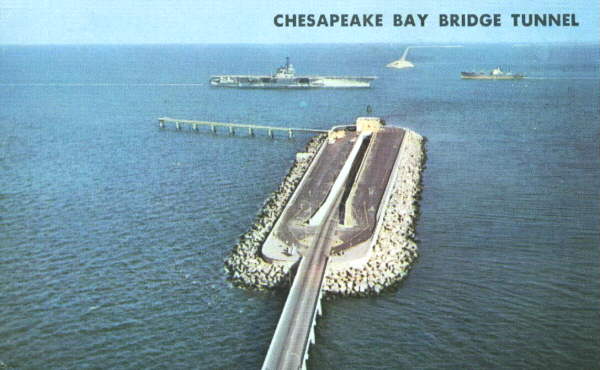
Drivers may stop at both the scenic overlook at the north end of the bridge and at Sea Gull Island, near the south end. At Sea Gull Island, passing ships may include U.S. Navy warships, nuclear submarines, and aircraft carriers, as well as large cargo vessels and sailing ships. The CBBT authority runs a restaurant and gift shop on the island. Fishing is encouraged from the 625-foot-long (191 m) pier, which is open 24 hours a day, year-round. Restrooms, fish-cleaning stations, and a certified fish weighing station are at the pier. Bluefish, trout, croaker, flounder, and other species have been caught from the pier. Since birds use the habitat created by the bridges and islands of the CBBT, birders have travelled to the bridge–tunnel to see them at Sea Gull Island and the scenic overlook at the north end.
Dimensions
Among the key features of the Chesapeake Bay Bridge Tunnel are two 1-mile (1.6 km) tunnels beneath Thimble Shoals and Chesapeake navigation channels and two pairs of side-by-side high-level bridges over two other navigation channels: North Channel Bridge (75 ft or 22.9 m clearance) and Fisherman Inlet Bridge (40 ft or 12.2 m clearance). The remaining portion comprises 12 miles (19 km) of low-level trestle, 2 miles (3.2 km) of causeway, and four man-made islands.The CBBT is 17.6 miles (28.3 km) long from shore to shore, crossing what is essentially an ocean strait. Including land-approach highways, the overall facility is 23 miles (37 km) long (20 miles or 32 kilometres from toll-plaza to toll-plaza) and despite its length, there is only a height difference of 6 inches (152 mm) from the south to north end of the bridge–tunnel.
Man-made islands, each approximately 5.25 acres (2.12 ha) in size, are located at each end of the two tunnels. Between North Channel and Fisherman Inlet, the facility crosses at-grade over Fisherman Island, a barrier island which is part of the Eastern Shore of Virginia National Wildlife Refuge administered by the U.S. Fish and Wildlife Service.
The columns that support the bridge–tunnel's trestles are called piles. If placed end to end, the piles would stretch for about 100 miles (160 km), roughly the distance from New York City to Philadelphia.
No comments:
Post a Comment